
US Army Corps of Engineers Lake Texoma forecast Update 6/02/2025
| Elevation | Date |
| 629 | 6/2/2025 |
| 628 | 6/5/2025 |
| 627 | 6/7/2025 |
| 626 | 6/8/2025 |
| 625 | 6/10/2025 |
| 624 | 6/11/2025 |
| 623 | 6/12/2025 |
| 622 | 6/13/2025 |
| 621 | 6/15/2025 |
| 620 | 6/16/2025 |
| 619 | 6/17/2025 |
“All Boaters continue to beware of potential hazards in the form of Floating Logs/Debris carried downstream into the lake due to the high inflows we have received. Be especially Cautious North of Roosevelt Bridge, and west of 377 Bridge.”
Lake Texoma as of June 2, 2025 is at 629.34 FT and slowly falling with an average inflow of 14,000 cfs. The latest forecast has the pool peaking to 630.7 ft on 5/30/2025. If conditions allow, we are looking to increase releases back to 41,000 cfs on Monday June 2nd. with rain in the forecast for next week in both the upstream and downstream watersheds, we will re-evaluate this daily and adjust the plan as necessary.
Pease use the forecasts as guidelines and know that the forecasts only consider rain that has been received on the ground and does not consider projected or forecasted rainfall. As a result, the forecasts are subject to change. Due to several days of extreme weather with rain and strong winds, most marinas are currently assessing damage and taking every precaution to minimize further damage. For everyone’s safety, some restrictions to access are in place. Please check with your marina directly with concerns you may have about your property.
Texoma Management team and Tulsa District Hydrology team are continuously working in coordination with SWPA on current and future release plans. As you are all aware there are numerous competing stakeholder interests involving Lake Texoma; to include, Flood Control, Water Supply, Hydroelectric Power, Regulation of Red River water flows, Improvement of Navigation, and Recreation. The USACE team strives to make the best resource decisions based on what is best for the mission, the Nation, and the public, understanding impacts to all stakeholders.
Lake Texoma Water Level June 3, 2025
| Lake Texoma Current water level is 628.93 feet and falling |
| Lake Texoma Water Level 9.93 ft ABOVE normal |
| Reservoir release 40,600 cubic feet per second |
| Gate release: 29,500 cfs |
| Turbine release: 11100 cfs |
| Gates: Open |
| Washita River @Cumberland Cut/Hwy 199 gauge: 628.84 feet |
| Inflow 14,000 CFS |
| Normal Elevation: 616.5′ |
| Hourly Data |
| Lake Texoma Fishing Report |
🚤⚠️ Attention Boaters on Lake Texoma! ⚠️🚤
When the water level is or has been high, so is the risk of hidden hazards lurking beneath the surface. Here are some crucial safety tips to keep in mind.

Marina and Campground updates
| Alberta Creek | RV Park & RV Park Road, Store, cafe, Road to Store/Cafe/, Boat Launch & Road to Boat Launch. Electricity to all docks will be shut off this afternoon. Rental units are not affected by water level. Boat ramp closed | |
| Big Mineral | Boat ramp closed; Power off for RV Sites and most boathouses | |
| Bridgeview Marina | Gas Dock, Boat Docks, and Boat ramp are all closed. A camp, C Camp, West Camp closed, limited spots in B Camp are usable | |
| Buncombe Creek | Cabin & RV Rentals available, Golf Cart Rentals available, General Store open, Twisted Anchor Grill & Patio Open, Boat ramp still good and fuel dock open | |
| Catfish Bay | The following sites are closed: CB115, 116, 117, 118, 119, 120, 121, 122, 123, 123, 125, 126, 127, 128, 85, 87, 88, 23 and 24 | |
| Cedar Mills | Electricity being turned off to the docks and Vacation Homes 16-20. Cedar Mills Road is closed, access to the marina is still available – proceed to Sherwood Grocery 2 miles north and come into the Marina via Hillcrest and county road. The entry road to Cedar Mills Resort is expected to be inaccessible on May 9th or when the water level reaches 636.All areas of the resort are closed until further notice, including Pelican’s Landing, RV Park and Cottages. Docks are available by shuttle only. Shuttle service: Saturday 9a until 4p (903) 523-4222X240; Sunday 9a until 2p (93) 523-4222 X222 | |
| Cedar Bayou | Limited access to slips (please use caution) Fuel Dock is closed. Marina open | |
| Eisenhower State Park | Swim Beach closed, boat ramp, Fishing Piers, all Trails are closed | |
| Eisenhower Yacht Club | The south cove road BH 22-31) is under water. Do not try to drive down this road. Mid cove road (BH 12-19) will be under water soon. All ramps are under water; Water is off to the entire marina; Shuttle boat is currently departing from Boathouse 1 | |
| Grandpappy Point Marina | Walkway access is fully submerged, and dock power has been shut off as well as the Fuel Dock. The Point Restaurant will be closed indefinitely – Mother’s Day Brunch this Sunday is cancelled. Customers utilizing the storage units above the 30/31 parking lot are advised to move their things to higher ground. | |
| Hagerman National Wildlife Refuge | The main road thru the refuge is completely submerged and blocked off. You can still get to the visitor center via Refuge Road. The bathroom at the Big Mineral picnic area is now partially submerged and Meadow Pond Road is impassable. Goode Day Use Area and Hallers Haven Trail open. May events have been cancelled. | |
| Highport Marina | The Island Bar & Grill is flooded. Water taxi is operating at the Fuel dock – operating day or night, rain or shine. | |
| Little Mineral | Lower parking lot clos, courtesy dock and boar ramp closed. Walkways are inaccessible, Power is currently off to some boathouses | |
| Marin del Rey | Suffered serious damage after Monday’s storms. Damaging winds set Boats adrift, Docks detached | |
| Mill Creek Marina | Boat ramp is currently closed. Oncor will probably turn off power to boat houses 1 – 7 on Saturday My 3rd, Currently water has been shut off for boathouse 7. | |
| Newberry Creek Marina | Boat ramp closed, please follow posted road signs/detours | |
| Walnut Creek | Power is off to boathouses and a few mobile homes, gate is closed to limit traffic to boat and home owners only. Boat ramp closed | |
| Willow Springs | WillowWipeout’s opening day may be delayed. Most cabins have been moved to higher ground and are not available; other lodging options remain open and available |
Campground Closures
| Buncombe Creek | A&B areas fully closed.C12-13 closed; Sites clsed through June 26, 2025; Boat Ramps closed |
| Caney Creek | Entire Park shut down through June 26, 2025, Boat ramp closed |
| Johnson Creek | Entire Park shut down through June 26, 2025, Boat ramp closed |
| Juniper Point East | Entire Park shut down through June 26, 2025, Boat ramp closed |
| Juniper Point West | Boat ramp closed |
| Lakeside | Entire Park shut down through June 26, 2025 |
| Platter Flats | sites B16-B23 and all of A-Loop Shut Down through June 26, 2025. boat Ramp Closed |
| Preston Bend | Entire Park shut down through June 26, 2025; Boat ramp closed |
| Spillway Boat Ramp | Closed until further notice due to construction |
| Texas Damsite | Entire Park shut down due to construction activities and not due to High Water. |
| West Burns Run | Entire Park shut down through June 26, 2025, Boat ramp closed |
IMPORTANT NOTICE:
Some Corps-owned facilities on Lake Texoma will close on October 1st and re-open in the Spring. All Corps of Engineers campgrounds are now self service – all sites are RESERVED only. QR Codes in the parks link to reservation Website.
If you are near the dam and hear the siren sound, you should prepare for a rapid change in water levels, because the siren signals that the amount of water being released is going to rapidly change. Boaters are also cautioned not to cross the buoy line at the intake structure as doing so puts you and the passengers in your boat in danger.
Helpful Links
Hourly lake level data: http://www.swt-wc.usace.army.mil/DENI.lakepage.html
- Fishing Reports
- Boat Ramps
- Corps of Engineers campground availability
- Oklahoma Road Conditions Map
- Drive Texas Road Conditions Map
News and Announcements
Corps of Engineer owned facilities update
Camping reservations link: https://www.recreation.gov/
Lake Texoma Trivia
- The top of the Denison Dam is 670 ft
- Water goes over the spillway at 640 ft.
- The Lake Texoma elevation hit a record high of 645.49 on May 29, 2015.
- The Roosevelt Bridge closed on May 30, 2015 when the lake level reached 645.66 ft.
- Lake Texoma crested June 1, 2015 at 645.72
This is what the Denison Dam Release of 43,653 cubic feet per second looks like! 326,568 gallons or 16 average size swimming pools per second! Video courtesy of Brad Rhodes 6/15/2019
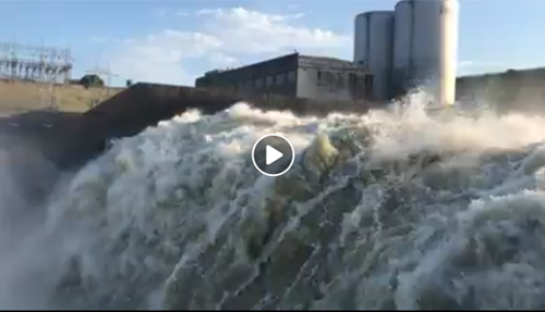
https://www.facebook.com/brhodes98/videos/pcb.10220461255980430/10220461241980080/
Thank you for visiting TexomaConnect.com! Free would be the Denison Damsite but there are no courtesy slips. The next closest would be Eisenhower State Park. There is a $5 park entrance fee and you might be able to use a courtesy slip at Eisenhower Yacht Club which is in the park. Also Grandpappy Point Marina has an inexpensive boat ramp and might have courtesy slips. Here are links to maps:
https://texomaconnect.com/business-directory-5/denison-damsite-campground/
https://texomaconnect.com/business-directory-5/eisenhower-state-park-lake-texoma/
https://texomaconnect.com/business-directory-5/grandpappy-point-resort-marina/
Hope this helps!
Hello,
We are new to Texoma and are looking for ramp access close to I75. Would prefer free and access to a courtesy slip as we have some little ones going with us. Can you recommend a good launch site like this or maybe something reasonable?
Thanks
Sorry, I don’t know but let me reach out to some of my contacts in the Kingston area and see if I can get an answer for you.
at what lake level does OU Biological road flood?
they haven’t sent me any status updates and everything seems to be fine at Marina del Rey.
What is the status of Marina Del Rey? Figures, they have no idea or do they care.
Thank you!
Wonderful, what a blog it is! This web site presents useful data to us, keep it up.
My family has been trying for two years have family reunion and this year we pray we can have great camp out from 20-22 and see family we have not saw years but with Lake water up out at East burn’s run we might not be able again plz open flood gates so people go out east burn’s run this Month see if wait 2 yr now plz oh Lord you hear my family prayer please bless us this year for we can come together as one amen
We are still in an El Nino weather pattern but it is much weaker than last year. Hopefully we will have a great big beautiful lake to play in this summer!
PLEASE SAVE OUR LAKE THIS YEAR!!