
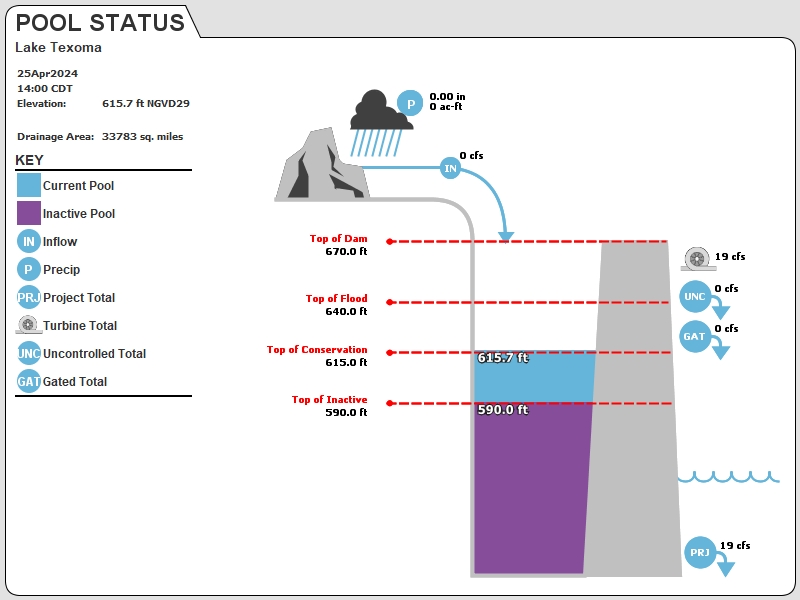
Current Lake Texoma Water Level
| Lake Level .73 ft ABOVE normal |
Lake Texoma Current elevation is 615.73 feet on 25APR2024 14:00 hours |
| At this elevation the total amount of water stored in Lake Texoma is 2393773 acre-feet. |
Reservoir release 19cubic feet per second on Thursday 25 Apr2024 14:00 hours |
| Normal Conservation Pool: 617′ |
Flood pool is 2.02% full. |
| Flood pool storage filled is 52329 acre-feet which is equivalent to 0.03 inches of runoff over the entire drainage basin |
Flood pool storage empty is 2539298 acre-feet which is equivalent to 1.41 inches of runoff over the entire drainage basin. |
Washita River @Cumberland Cut/Hwy 199 gauge: 615.57 feet on 256APR2024 10:00 hours |
Inflow 0 CFS 25APR2024 14:00 hours |
| Gates: CLOSED |
| Hourly Data |
| Lake Texoma Fishing Report |
Helpful Links
Hourly lake level data: http://www.swt-wc.usace.army.mil/DENI.lakepage.html
- Fishing Reports
- Boat Ramps
- Corps of Engineers campground availability
- Oklahoma Road Conditions Map
- Drive Texas Road Conditions Map
Last Flood Gate Change
Tuesday, 25 Oct 2022 0845
Conditions at the time of Gate Change
- Pool Elevation = 614.38 feet.
- Total Release = 0 (cfs)
- Gate Release =0 (cfs)
- Unregulated Release = 0 (cfs)
- Turbine Release 19 (cfs)
- Gate Settings: All CLOSED
Please note that the forecasts only take into account rain on the ground. As a result, the forecasts are subject to change as soon as any type of rain event occurs.
IMPORTANT NOTICE:
If you are near the dam and hear the siren sound, you should prepare for a rapid change in water levels, because the siren signals that the amount of water being released is going to rapidly change. Boaters are also cautioned not to cross the buoy line at the intake structure as doing so puts you and the passengers in your boat in danger.
News and Announcements
Corps of Engineer owned facilities update
Some Corps-owned facilities on Lake Texoma will close on October 1st and re-open in the Spring. All Corps of Engineers campgrounds are now self service – all sites are RESERVED only. QR Codes in the parks link to reservation Website.
Camping reservations link: https://www.recreation.gov/
Winter Camping and boat launch facilities that are open
Lake Texoma Trivia
- The top of the Denison Dam is 670 ft
- Water goes over the spillway at 640 ft.
- The Lake Texoma elevation hit a record high of 645.49 on May 29, 2015.
- The Roosevelt Bridge closed on May 30, 2015 when the lake level reached 645.66 ft.
- Lake Texoma crested June 1, 2015 at 645.72
This is what the Denison Dam Release of 43,653 cubic feet per second looks like! 326,568 gallons or 16 average size swimming pools per second! Video courtesy of Brad Rhodes 6/15/2019
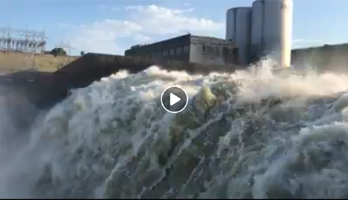
https://www.facebook.com/brhodes98/videos/pcb.10220461255980430/10220461241980080/
Thank you for visiting TexomaConnect.com! Free would be the Denison Damsite but there are no courtesy slips. The next closest would be Eisenhower State Park. There is a $5 park entrance fee and you might be able to use a courtesy slip at Eisenhower Yacht Club which is in the park. Also Grandpappy Point Marina has an inexpensive boat ramp and might have courtesy slips. Here are links to maps:
https://texomaconnect.com/business-directory-5/denison-damsite-campground/
https://texomaconnect.com/business-directory-5/eisenhower-state-park-lake-texoma/
https://texomaconnect.com/business-directory-5/grandpappy-point-resort-marina/
Hope this helps!
Hello,
We are new to Texoma and are looking for ramp access close to I75. Would prefer free and access to a courtesy slip as we have some little ones going with us. Can you recommend a good launch site like this or maybe something reasonable?
Thanks
Sorry, I don’t know but let me reach out to some of my contacts in the Kingston area and see if I can get an answer for you.
at what lake level does OU Biological road flood?
they haven’t sent me any status updates and everything seems to be fine at Marina del Rey.
What is the status of Marina Del Rey? Figures, they have no idea or do they care.
Thank you!
Wonderful, what a blog it is! This web site presents useful data to us, keep it up.
My family has been trying for two years have family reunion and this year we pray we can have great camp out from 20-22 and see family we have not saw years but with Lake water up out at East burn’s run we might not be able again plz open flood gates so people go out east burn’s run this Month see if wait 2 yr now plz oh Lord you hear my family prayer please bless us this year for we can come together as one amen
We are still in an El Nino weather pattern but it is much weaker than last year. Hopefully we will have a great big beautiful lake to play in this summer!
PLEASE SAVE OUR LAKE THIS YEAR!!